顾及时空特性的的MODIS地表温度降尺度算法研究
首发时间:2020-11-23
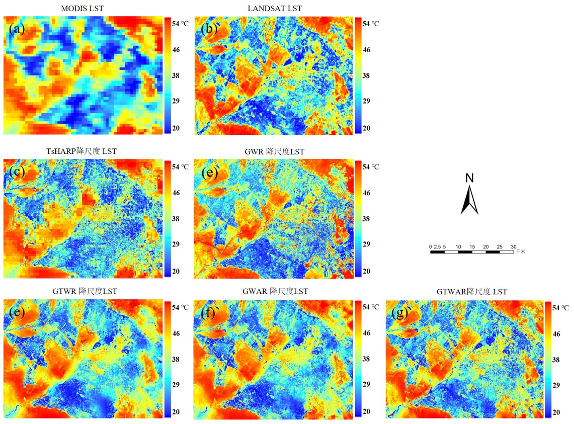
摘要:地表温度(LST)是许多热环境研究中的一个关键参数。在目前的技术条件下,卫星传感器无法同时提供高时空分辨率的地表温度数据。地表温度降尺度是解决这一问题的有效途径,通过降尺度算法可以有效提高地表温度数据的时空分辨率。本文综合考虑地表温度及相关数据的空间异质性、空间自回归性与时间特性,提出了一种时空地理加权自回归降尺度模型(Geographically and Temporally Weighted Autoregression,GTWAR)。以张掖为研究区域,选取归一化水体指数,归一化建筑指数,归一化植被指数作为解释变量,将中分辨率成像光谱仪地表温度产品MOD11A1从1000m空间分辨率降尺度到100m。接着将Landsat8 LST作为参考数据,进行对比发现基于GTWAR模型的降尺度算法相较于TsHARP、GWR、GWAR、GTWR在研究区内具有更低的均方根误差(1.57℃)和平均绝对误差(1.06℃),R2达到了0.90。最后总结了关于GTWAR模型降尺度算法数据选取的注意事项。
关键词: 地表温度 时空异质性 时空自相关性 时空地理加权自回归 降尺度?????
For information in English, please click here
Spatial Downscaling of MODIS Land Surface Temperature with Considering Temporal and Spatial Characteristics
Abstract:Land surface temperature (LST) is a key parameter in many thermal environment studies.Under the current technical conditions, satellite sensors cannot provide surface temperature data with simultaneous high spatial and temporal resolution. LST downscaling algorithm is an effective way to solve this problem, which can effectively improve the temporal and spatial resolution of surface temperature data. A Geographically and Temporally Weighted autoregressive (GTWAR) model of LST downscaling is proposed by considering the spatial heterogeneity, spatial autoregressive and temporal characteristics of LST comprehensively. The study took Zhangye as the research area. The normalized water index (NDWI), normalized building index (NDBI) and normalized vegetation index (NDVI) were selected as explanatory variables to enhance the spatial resolution of MOD11A1, the surface temperature product of the moderate resolution imaging spectroradiometer (MODIS), from 1000m to 100m. Then Landsat8 LST was used as the reference data, and it was found that compared with TsHARP GWR GWAR GTWR, the downscaling algorithm based on GTWAR model had lower RMSE (1.57) and MAE (1.06) in the study area, and R2 in study area reached 0.90. Finally, the points for attention in data selection of downscaling algorithm based on GTWAR model are summarized.
Keywords: land surface temperature spatio-temporalautocorrelation spatio-temporalheterogeneity geographically and temporally weighted autoregressive spatial downscaling
基金:
论文图表:
引用


No.****
动态公开评议
共计0人参与
勘误表
顾及时空特性的的MODIS地表温度降尺度算法研究
中国科技论文在线 版权所有
网站地图|
在线首页|
在线简介|
服务条款|
联系我们

京公网安备 11040202430024号 京ICP备15006316号-2| 网络出版服务许可证 (总)网出证(京)字第083号 | 文保网安备案号:1101080066


 .txt
.txt .ris
.ris .doc
.doc
评论
全部评论